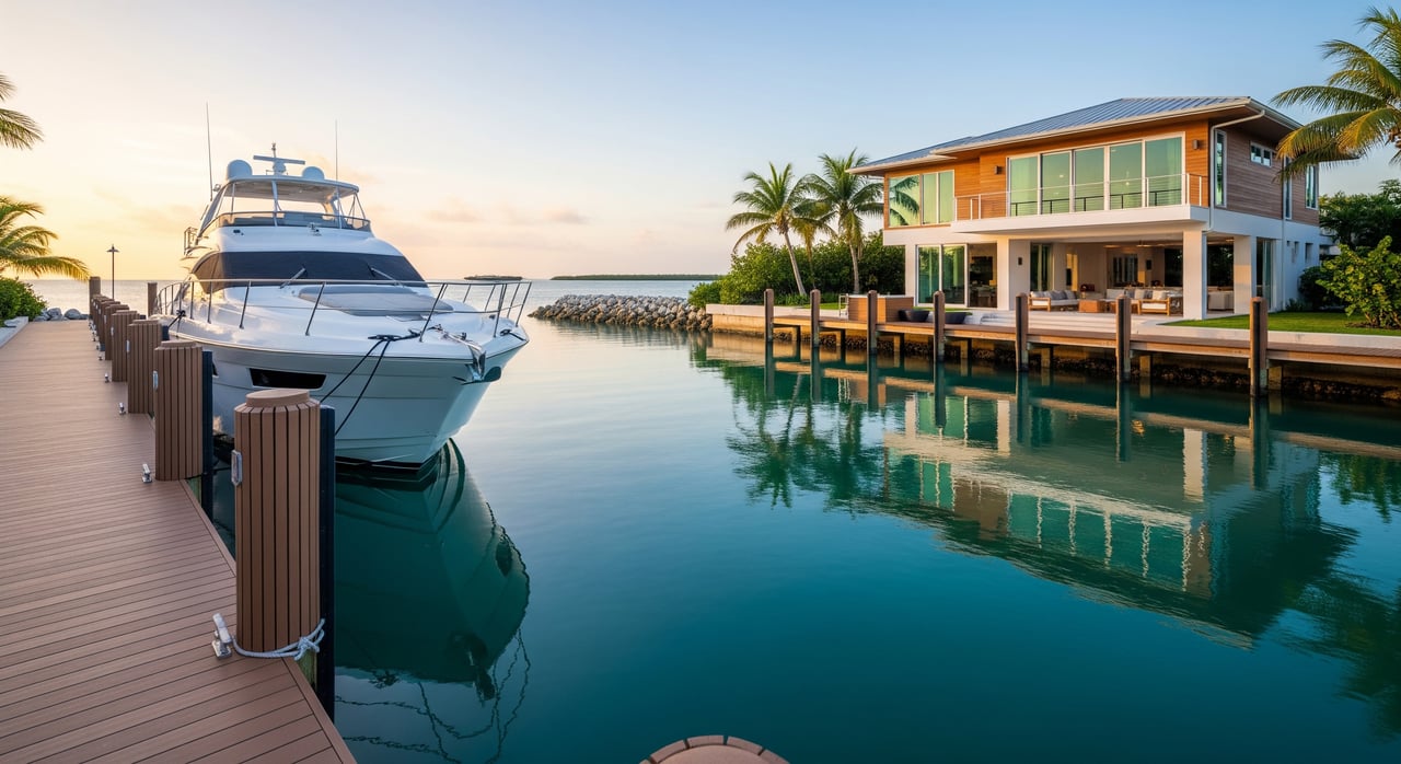
Bringing a serious boat to Coco Plum Terraces and wondering if “deep‑water dockage” really means you can clear the canal at low tide? You are not alone. In the Middle Keys, the phrase is common in listings, yet it can mean different things depending on the canal, dredging history, and your vessel. This guide explains how “deep water” is used locally, how to verify actual depths and clearances, and how to plan your draft so you can get from your dock to open water with confidence. Let’s dive in.
“Deep‑water” in the Middle Keys
“Deep‑water” is a marketing term, not a legal standard. In the Marathon area, it usually signals that a dock and its approach canal are navigable for typical recreational boats under normal tides. The catch is that there is no single number that defines it. One property’s “deep” may suit center consoles, while another may still be tight for a deep‑keel sailboat.
Treat any “deep‑water” claim as a starting point. Ask for the measured depth at the dock and at the canal entrance, the tidal datum used for that measurement, and when the canal or basin was last dredged. Those details tell you what is usable at the lowest tides, not just on a good day.
A working definition for Coco Plum
For practical planning, you can read “deep‑water” around Coco Plum as depth that supports typical Florida recreational boats at usual tidal conditions. To make that real, always request the depth at Mean Low Water (MLW) or Mean Lower Low Water (MLLW) and the date of the last sounding or dredge.
Typical canal depths in Marathon
Canal systems across Marathon were dredged at different times and are maintained to different standards. As general guidance, many private residential canals range from about 3 to 5 feet at low water on the shallow side, up to roughly 6 to 8 feet at low water in better‑maintained or purpose‑dredged sections. Public navigation channels and some marina basins are often deeper, commonly around 8 to 12 feet or more. Local variation is significant, and shoaling can change conditions over time, so verify each property.
Verify a specific dock or canal
Ask for documentation and cross‑check with authoritative sources. You can:
- Request the recorded depth at the dock and at the canal entrance, the reference datum used (MLW, MLLW, or LAT), and the date of the measurement.
- Ask for permits or surveys that include soundings, as well as the date of last dredging.
- Review local government or HOA records for dredging and maintenance history.
- Consult official nautical charts for channel soundings and entrance depths.
- Speak with a local marina, marine surveyor, or harbormaster for current shoaling updates.
- If exact numbers matter, commission a professional sounding or hire a local captain to run the approach near low water.
Tides and datums you must confirm
The Keys are microtidal compared to many coastal markets, but the tide still matters when your under‑keel clearance is tight. Spring tides, wind setup, and barometric pressure can add or subtract meaningful inches from expected water levels in a canal.
Depth statements are only as useful as the datum behind them. You will commonly see depths referenced to MLLW, MLW, or Lowest Astronomical Tide (LAT). A depth of “6 ft at MLLW” is more conservative than “6 ft at MLW,” which affects how much water you can count on at the lowest tides.
For transit planning, check tide predictions for the Marathon area for your actual date and time, then layer on weather factors. Even modest, sustained winds can push water out of a canal and reduce usable depth. Ask for depth at MLW or MLLW, then confirm the predicted tide for your window of travel.
Bridge and overhead clearance
If you plan to bring a sailboat or a towered center console, vertical clearance can limit your route. Some canal systems reach open water with no bridge restrictions, while others may require passing under fixed spans or using movable bridges.
Check official nautical charts for the vertical clearance noted at chart datum, and identify whether any bridges on your route are fixed or opening. If a movable bridge is involved, confirm the opening schedule. When you compare your vessel’s air draft to charted clearance, include the predicted tide at your planned transit time, and build in a conservative buffer for swell and vessel motion.
Plan for your boat’s draft
Draft planning is where numbers matter. Keep these definitions and ranges in mind:
- Draft, static: Waterline to the lowest point of the hull or keel at rest.
- Air draft: Waterline to the highest point above deck, important for bridges.
- Squat and dynamics: When underway, many boats sit lower, which increases effective draft.
- Under‑keel clearance (UKC): The safety margin between your keel and the bottom.
Typical draft ranges for planning:
- Small center consoles and bay boats: about 8 to 30 inches.
- Larger center consoles: roughly 2 to 3 plus feet.
- Shoal‑keel cruising sailboats: about 4 to 5 feet.
- Deep‑keel performance sailboats: 6 feet and up, some 7 to 8 plus feet.
A practical UKC guideline for sheltered waters is at least 10 percent of your draft or 1 foot, whichever is larger. Many skippers prefer 1 to 2 feet. If a canal is reported at 6 feet at MLLW and your sailboat drafts 5 feet, the paper math leaves only 1 foot before squat or silt. That is tight, so plan conservatively and consider tide windows.
Buyer checklist for Coco Plum dockage
Use this step‑by‑step process to confirm your vessel will truly fit:
- Get the numbers from the seller or HOA
- Depth at the dock and at the canal entrance, and the tidal datum used.
- Date of last sounding and last dredging.
- Any maintenance commitments that affect depth.
- A route map from the dock to the nearest main channel and to open water.
- Cross‑check official charts
- Review current chart soundings for the entrance and route.
- Confirm the chart’s tidal datum.
- Use electronic charts as a supplement, not a sole source.
- Check the tide for your transit window
- Look up the predicted tide for your planned arrival or departure time.
- Add the predicted tide level to charted depths to estimate real‑time water.
- Add safety margins
- Include UKC and an allowance for squat under power.
- Consider wind and pressure that can lower water levels in canals.
- Verify bridges and air draft
- Compare your air draft to charted clearances, adjusted for tide.
- Get local confirmation
- Call nearby marinas, the harbormaster, or a local captain for current route conditions.
- Hire a surveyor for a sounding or a captain to test the transit at low water if needed.
- Document everything
- Keep any depth surveys, permits, and measurements with their dates and datums.
Red flags to watch
- Depths reported without a tidal datum.
- Old surveys with no recent dredging or maintenance history.
- Reports of shoaling at the canal entrance.
- Bridge clearances listed without a reference level or tide adjustment.
- Vague answers about current vessel sizes using the dock.
Smart questions to ask
- What is the recorded depth at the dock and at the canal entrance, and what datum is it referenced to?
- When was the last sounding or dredge, and can I review the survey or permit?
- Can you show me the route to open water and identify any bridges or obstructions?
- What sizes and types of vessels currently use this dock or canal on a regular basis?
If depth is marginal
You still have options if your numbers are tight:
- Keep the boat in a deeper nearby marina, then tender to your dock.
- Use passenger transfer solutions that let the primary vessel stay off the dock.
- Time your arrivals and departures to favorable tides.
- Commission a local captain to confirm the route during low water before you commit.
How a boutique advisor helps
Out‑of‑area buyers often need a local partner who knows which canals are reliable, which require timing the tide, and where shoaling tends to show up. A boutique, hands‑on approach can coordinate depth surveys, review permits and HOA records, liaise with marinas and local captains, and organize a low‑water test transit before you close. That is how you protect both your boating lifestyle and your investment.
If you are weighing a Coco Plum Terraces property and want clear answers on dockage, reach out. Tracy Chacksfield brings a concierge process, local market authority, and a trusted vendor network to help you verify the numbers and close with confidence.
FAQs
What does “deep‑water dockage” mean in Marathon?
- It is a marketing term that usually signals navigable depth for typical recreational boats under normal tides. Always ask for depth at MLW or MLLW and the date of the last dredge or sounding.
How do Keys tides affect my boat clearance?
- The Keys are microtidal, but spring tides, wind, and pressure can change water levels enough to matter. Check tide predictions for your transit time and add a safety margin.
What is the best way to verify a property’s canal depth?
- Request measured depths with the tidal datum and survey date, review official charts for the entrance channel, and confirm with local marinas or a professional sounding.
How much under‑keel clearance should I plan for?
- A common guideline in sheltered waters is at least 10 percent of your draft or 1 foot, whichever is larger. Increase the margin for unfamiliar canals or tight approaches.
Are there bridge clearance issues from Coco Plum to open water?
- Some routes have no vertical restrictions, while others involve fixed or movable bridges. Compare your air draft to charted clearances and adjust for the predicted tide before transiting.