Shopping canal-front in Key Colony Beach can feel thrilling and tricky at the same time. Not all canals, docks, or routes to open water are the same. You want smooth boating, safe dockage, and simple day-to-day use. In this guide, you will learn the exact measurements to verify, how city and state rules affect your choices, and what to check on site before you make an offer. Let’s dive in.
The three must-check measurements
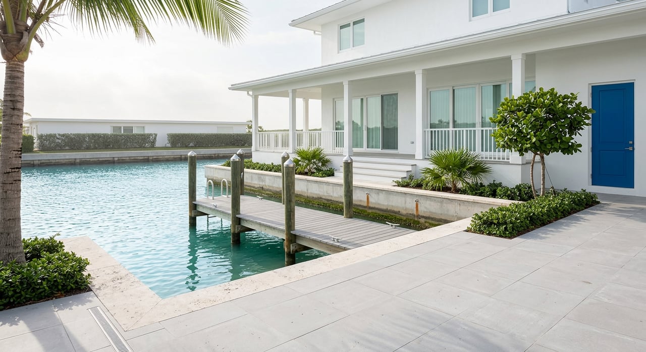
Verify usable dock length
Advertised dock length does not always equal usable space. Ask for the true, usable linear length where a boat can tie safely. Hardware, platforms, and pilings can shrink the space you actually have. City rules also matter: Key Colony Beach ties overall boat length to the waterfront property lines, and the city prohibits rafting and living aboard. You can review the city’s operational rules in the City’s published guidance on IDLE-SPEED/NO-WAKE zones, rafting, and boat length limits in Key Colony Beach rules and regulations.
Check fairway width and turning room
Canal width and clear fairway control how easily you can approach, turn, and depart in wind or current. A common small‑craft planning guideline suggests a fairway width about 1.5 to 1.75 times your boat length for comfortable maneuvering. If you expect to keep a larger vessel, ask for a real turning demonstration with similar-size boats. You can read more about fairway planning guidance in this marina design reference on recommended fairway width for small craft.
Confirm depth at mean low water
Depth at mean low water, not just “average depth,” is what protects you from groundings. In the Florida Keys, state dock‑siting policy uses minus four feet at mean low water as a key threshold for locating facilities in adequate depth. Some canals and basins will be deeper, but you should still request a recent sounding referenced to MLW. The controlling state policy is the Florida Keys Marina and Dock Siting Policies (Rule 18‑21). For local tide datum and predictions, rely on NOAA’s Key Colony Beach station listed on the Sadowski Causeway at NOAA Tides and Currents station 8723962.
Access to Vaca Cut and bridges
Routes to Vaca Cut and beyond
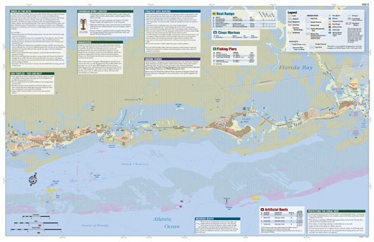
Most Key Colony Beach canals offer quick runs to Vaca Cut and the nearby marked channels used by Marathon‑area boaters. To visualize the route and channel markers, use the Middle Keys sheet in Florida Fish and Wildlife’s boating atlas at the FWC Middle Keys boating map. Homes closer to canal mouths or turning basins often enjoy faster open‑water access.
Bridge clearances and tall profiles
If you plan to store a tall hardtop, tower, or mast, verify vertical clearances for the Sadowski Causeway and any other bridges on your route. Check local NOAA resources for datum and nearby bridge references through NOAA’s Key Colony Beach station page, then confirm against current charts before you buy.
Idle speed and no‑wake rules
All city waterways require IDLE‑SPEED/NO‑WAKE. The rule reduces wake damage and improves safety, but it also adds transit time in and out of the canals. The city also prohibits rafting and living aboard. Review these everyday rules in the city’s published guidance here: Key Colony Beach rules and regulations.
Wind orientation and exposure
Canal orientation shapes your day-to-day comfort at the dock. Seasonal winds in the Keys tend to be more easterly in the wet season and shift more northerly in the dry season. Canals that face into the dominant winds can see more chop and reflected wake. That can change your fendering plan and hardware choices. For seasonal wind patterns in the region, review this study on prevailing wind and exposure in Florida waters.
Docks, seawalls, and permitting
Dock types and lift capacity
You will see a mix of fixed docks, small floating sections, and boat lifts tied to concrete seawalls throughout Key Colony Beach. Confirm the lift’s rated capacity against your vessel and that the full advertised dock length is usable for your beam and lines. If you plan to add services like a pump‑out, confirm what permits are required and where the nearest pump‑out is available through the County’s Marina Pump‑Out Program. For nearby fuel and service context, historical planning documents list a local marina presence on the Sadowski Causeway; see the reference in the USCG Florida Keys Area Contingency Plan.
Seawalls and record checks
Seawall condition, elevation, and repair history affect long‑term costs and insurance. Ask for as‑builts, engineering reports, and proof of permits on any past or pending seawall or dock work. City and County building departments hold the records. A starting point for local records and meeting materials is here: City of Key Colony Beach meeting documents.
Permitting and depth limits
The state’s dock‑siting policy sets expectations for depth and limits new dredging for access. That means you should match your boat’s draft to existing depths rather than plan to deepen a canal. Review the state policy at Florida Keys Marina and Dock Siting Policies and confirm whether any part of a dock sits over sovereignty submerged lands that could require leases or special approvals.
On‑site buyer checklist
Use this quick checklist when you tour canal homes in Key Colony Beach. Confirm each item on site and in records when possible.
- Usable dock length. Measure the true tie‑up distance and confirm lift capacity if present. See city rules on boat length vs. lot frontage in the Key Colony Beach rules and regulations.
- Canal width and fairway. Ask for measured canal width across from the dock and watch a similar‑size boat turn. For guidance, note the 1.5 to 1.75 times boat length rule of thumb for maneuvering.
- Depth at mean low water. Request a recent sounding at MLW and tie it to tide datum from NOAA’s Key Colony Beach station. Compare to the state’s depth threshold in Rule 18‑21.
- Orientation and exposure. Note which way the canal opens and compare to seasonal winds discussed in this wind and exposure study.
- Proximity to open water. Locate the property on the FWC Middle Keys boating map and identify the run to Vaca Cut.
- Bridge and channel constraints. Confirm vertical clearances for the Sadowski Causeway and any route bridges using NOAA station data and charts.
- Permits and history. Pull permits and records for docks and seawalls through City Hall and County records; start with City meeting and records links.
- Utilities and services. Verify shore power, water, and the nearest pump‑out via the County’s Marina Pump‑Out Program. Check for nearby fuel and service context in the USCG contingency reference.
- Environmental limits. Ask about seagrass presence or Sanctuary constraints, then compare your findings to the FWC boating guide map.
- Neighborhood rules and enforcement. Review City rules on no‑wake, rafting, and boat length and ask for any code enforcement history at Key Colony Beach rules and regulations.
Bring it all together
A great canal home gives you the right dock length, enough fairway to maneuver, reliable depth at MLW, and a smooth path to Vaca Cut. When you layer in City rules, bridge clearances, wind exposure, and clean permit history, you can buy with confidence and enjoy your boat from day one. If you would like help touring options, arranging on‑water checks, and coordinating records with City Hall, reach out to Tracy Chacksfield to schedule a tour.
FAQs
What should I measure first on a Key Colony Beach canal property?
- Start with usable dock length, canal fairway width, and depth at mean low water. These three items control boat size, maneuvering, and everyday access. See the state depth threshold in Rule 18‑21.
How do local rules affect my boating from a canal home?
- Key Colony Beach enforces IDLE‑SPEED/NO‑WAKE, prohibits rafting and living aboard, and ties boat length to your lot’s waterfront. Review details in the City’s rules and regulations.
How can I verify canal depth and bridge clearance before I buy?
- Request a recent depth sounding referenced to MLW and cross‑check tide datum at NOAA station 8723962. Confirm bridge clearances against current charts for your route.
Which maps show my route to Vaca Cut and open water?
- The FWC Middle Keys boating map shows dredged channels, Vaca Cut, and local approaches used by recreational boats.
Who handles pump‑outs and what services are nearby?
- Not every home has on‑site services. Check the County’s Marina Pump‑Out Program and confirm fuel or service options referenced in the USCG contingency plan.
Do I need permits to repair or replace a seawall or dock?
- Yes. Seawall and dock work typically requires permits and may involve environmental review. Pull records through City Hall and confirm compliance before you proceed. A starting point for local records is the City’s public documents.